BMW Maps To Combine Navigation And Driver Assistance In New 3D Display
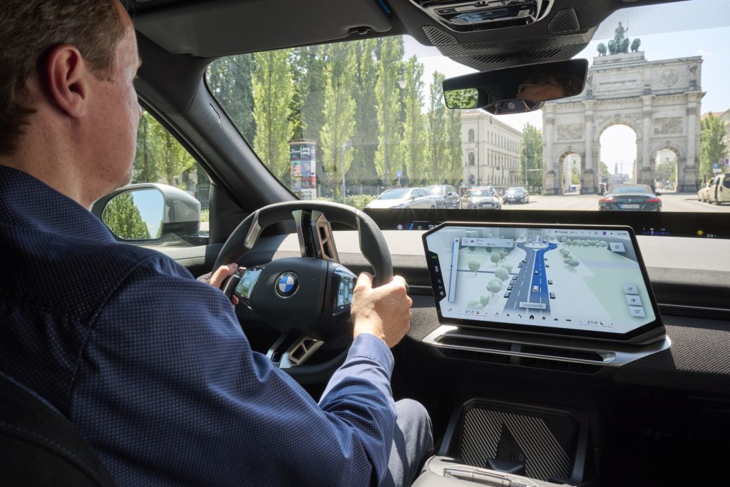
BMW is preparing to introduce a major update to its in-car navigation technology, bringing mapping, surrounding traffic and driver-assistance information together in a single three-dimensional display.
From October 2026, BMW Maps with Driver Assistance will begin rolling out to compatible BMW models equipped with BMW Operating System X. The system is intended to give drivers a clearer picture of not only where they need to go, but also what the car’s assistance technology can detect around them.
The new interface places the driver’s vehicle accurately within its lane and at the correct road level, which BMW says should make the display particularly useful on motorways, at complicated junctions and in busy urban environments.
Rather than presenting navigation and driver-assistance functions as largely separate systems, BMW is effectively combining them into one visual representation of the journey.
Drivers Can See What The Car Sees
One of the most interesting elements of the technology is its ability to show how the vehicle perceives its surroundings.
Alongside conventional route guidance, drivers will be able to see information relating to the assistance systems currently supporting them. BMW believes this should make assisted and semi-automated driving easier for motorists to understand.
The technology becomes particularly relevant when assistance systems are taking a more active role over longer journeys.
BMW’s Highway Assistant 2, for example, can support hands-free motorway driving at speeds of up to 130km/h – around 81mph. It controls longitudinal and lateral vehicle movement and can support automated lane changes after confirmation from the driver through a glance.
When BMW Maps route guidance is active, the system can provide assistance from the motorway entry slip road through to the driver’s required exit.
Urban Semi-Automated Driving Coming From 2027
BMW’s ambitions extend beyond motorways.
From 2027, models running Operating System X are due to begin receiving navigation-guided semi-automated driving capabilities for urban environments, initially in Germany.
That makes the integration between mapping and assistance systems increasingly significant. A vehicle capable of assisting with driving needs detailed information about where it is going as well as an understanding of its immediate surroundings.
Stephan Durach, Senior Vice President of Digital Services, Infotainment and Connected Company at BMW Group, said:
“An important step toward highly automated driving is the intelligent interaction between navigation and driver assistance.”
He said the new system would help drivers understand how route guidance, environmental perception and assistance functions are working together.
BMW Works With Mapbox On New System
BMW Maps with Driver Assistance has been developed by BMW Group and uses navigation data and mapping technology supplied by Mapbox.
The integrated display combines mapping information with data from vehicle sensors and artificial intelligence to produce the 3D representation presented to the driver.
Peter Sirota, CEO of Mapbox, said the system would allow motorists to see which lane they need to use while simultaneously displaying relevant activity around their vehicle.
The result is intended to make increasingly sophisticated driver-assistance technology easier to interpret without forcing motorists to mentally combine information presented in different areas of the car’s interface.
Not Every BMW Will Get The Feature
There are some important limitations to the rollout.
BMW says Maps with Driver Assistance will only be available in conjunction with Highway Assistant or Highway & City Assistant, and availability will depend on the country, city and road.
The introduction will also take place in phases, while the precise capabilities and limitations of BMW’s Highway Assistant and Highway & City Assistant systems differ between countries.
For compatible vehicles, however, the October update represents another indication of how quickly the role of in-car navigation is changing.
The traditional sat-nav primarily told drivers where to turn. BMW’s new approach is considerably more ambitious, using the map as a visual interface connecting navigation with the vehicle’s increasingly sophisticated understanding of the road around it.
As assisted driving develops further, that ability to clearly communicate what the car sees, what it intends to do and where it needs to go next could become as important as the underlying automation itself.